Services

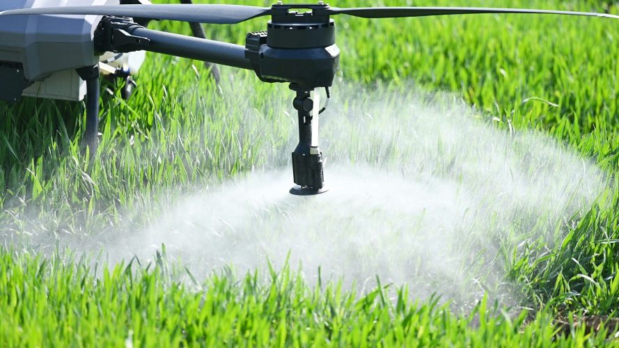
Aerial Spraying- Coming Soon!
Drone spraying uses advanced unmanned aircraft to precisely apply herbicides, insecticides, foliar products and fungicides. By flying low and targeting specific areas, drone applications reduce crop damage, minimize chemical waste, and improve efficiency compared to traditional ground rigs or manned aircraft. It’s a smarter, more precise way to protect and enhance your fields.
Coming Soon — Full agricultural spraying services will be available upon final approvals and exemptions from the Federal Aviation Administration. In the meantime, Plains Precision is fully operational for aerial mapping, crop health analysis, thermal recovery, and other precision drone services.
Cover Crop Seeding- Coming Soon!
Drone seeding is one of the most efficient ways to establish cover crops. By broadcasting seed from above, drones can access fields when ground equipment can’t — including wet soils, standing crops, tall residue, or late-season conditions. There’s no soil compaction, no crop damage, and no ruts left behind. Drones allow for precise rate control and targeted placement, making it ideal for interseeding into corn or soybeans, seeding after harvest, or reaching hard-to-access acres.
Coming Soon — Full agricultural seeding services will be available upon final approvals and exemptions from the Federal Aviation Administration. In the meantime, Plains Precision is fully operational for aerial mapping, crop health analysis, thermal recovery, and other precision drone services.

Crop Health Analysis
Crop health analysis uses advanced multispectral drone imaging to reveal what the eye can’t see. With the DJI Mavic 3 Multispectral and professional processing through Pix4Dfields, Plains Precision captures detailed data across multiple light bands — including near-infrared and red-edge — to measure plant vigor, chlorophyll activity, and field variability.
The result is clear, actionable vegetation index maps such as NDVI, NDRE, and other vegetation indices that help identify stress, nutrient deficiencies, drainage issues, and uneven growth. Instead of guessing, you can scout the right areas, fine-tune input applications, and make confident management decisions that improve efficiency and protect yield potential.
It’s precision intelligence for modern farming — delivered quickly, accurately, and ready to guide your next move.

Field Mapping
Field mapping provides high-resolution aerial maps that give you an accurate, up-to-date view of your fields. Plains Precision delivers detailed orthomosaic maps and elevation models that help measure acreage, identify drainage patterns, and evaluate overall field conditions.
One of the greatest advantages is integration — these maps can be uploaded into compatible farm equipment to create accurate field boundaries and guidance lines. The result is cleaner passes, more consistent coverage, improved efficiency, and optimized input use. It’s precise data that works seamlessly with your equipment to reduce overlap, cut waste, and save time and money.

Thermal Recoveries
Using advanced thermal drone technology, Plains Precision can detect heat signatures that aren’t visible to the naked eye — making it a powerful tool for livestock recoveries, herd management, and pet recoveries. Whether locating missing cattle in timber and tall grass, monitoring herd movement across large pastures, or keeping an extra set of eyes on livestock during calving season, thermal imaging provides fast, efficient insight without disturbing animals.
In rural Kansas, when pets run off, they often disappear into thick timber, tall grasslands, or wide open country where finding them quickly becomes difficult. Our thermal drone recovery services help locate missing pets faster by detecting body heat, even in dense cover or low visibility conditions. We provide a safe, efficient way to bring your animals home when every minute counts.
It’s a safe, minimally intrusive way to cover ground quickly, protect your investment, and bring pets home sooner.

Real Estate Imaging
Drone real estate imaging gives property listings a striking visual edge by capturing crisp aerial photos and smooth video that highlight every angle of a home and its surrounding land. Equipped with a high-resolution 100 MP Hasselblad camera and advanced triple-lens system, this platform delivers detailed 6K video and expansive stills that bring out features buyers care about — from roof lines and landscaping to acreage and access points.
The drone’s intelligent flight modes, stabilized gimbal, and long flight time allow for dynamic walk-throughs, wide overview shots, and cinematic sequences that enhance listings, showcase property scale, and help makers stand out in competitive markets.
Whether used for residential, commercial, or rural properties, professional aerial imaging makes listings more engaging, builds buyer confidence, and adds a premium feel to marketing materials.
About Plains Precision
Plains Precision was founded in Clifton, Kansas with one goal in mind — help producers farm smarter, faster, and more efficiently using cutting-edge drone technology.
We provide precision aerial services across Cloud, Republic, Clay, and Washington counties, delivering actionable data and targeted applications that reduce waste, protect yields, and save time. From aerial spraying and cover crop seeding to crop health analysis, high-resolution NDVI mapping, thermal recovery, and aerial imaging, our mission is simple: bring modern precision tools to the hardworking producers of rural Kansas.
As a locally owned and operated company, we understand the land, the weather, and the challenges our neighbors face. We combine agricultural experience with advanced UAV systems to offer reliable, responsive service you can trust.
At Plains Precision, technology isn’t replacing tradition — it’s strengthening it.
Contact Us
Fill out the form to request a quote or schedule a demo of our drone services.


Urgent?
Nick Kennedy- Owner/Operator
Email: nkennedy@plainsprecision.com
Call/Text: 785-614-0307
Clifton, KS 66937